FREE & QUICK WORLDWIDE SHIPPING ON $60+
TAKE 10% OFF YOUR ORDER | USE CODE: TAKE10
Book details
-
 xvi+442p., Illustrations; Full of Col; Maps; 36cm.
-
 Hardcover
-
 English language
-
 Asiatic Society of Bangladesh
-
 31.12.2018
-
 ISBN 10:
978984931
ISBN 10:
978984931
Related categories
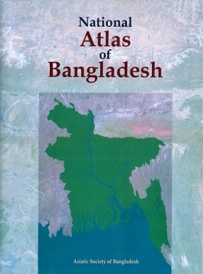
National Atlas of Bangladesh
Synopsis
The National Atlas of Bangladesh is a comprehensive collection of maps prepared to portray the spatial dimensions of the country's historical, politico-administrative, physical, environmental, infrastructural, demographic, economic, social, cultural and regional/local features. The large volume of maps, 425 in number, visually illustrate the impressive records of development in independent Bangladesh. The maps are accompanied by short texts, tables and figures.
Content: Section 1: From Vanga to Bangladesh Historical Geography; Section 2: Political and Administrative Units; Section 3: Physical and Environmental Setting; Section 4: Environmental Concerns: Natural Hazards and Disasters; Section 5: Agriculture, Livestock and Poultry; Section 6: Minerals, Energy, Industry and Tourism; Section 7: Transport, Communication and Media; Section 8: Population; Section 9: Labour Force and Economic Activity; Section 10: Urbanization; Section 11: Housing and Utilities; Section 12: Human Development: Education, Health, Nutrition, GDP and Poverty; Section 13: Culture and Heritage; Section 14: Bangladesh in International Contexts; Section 15a: Administrative Units: Divisions; Section 15b: Administrative Units: Districts; Section 15c: Administrative Units: City Corporations and Paurashavas; Section 16: Capital Planning and Development: Dhaka Metropolitan Region (DMR).
-10%
Item available. Ships in days.
Share

Nazrul Islam

About the author
View books
Nurul Islam Nazem
About the author
View books
Explore titles by the author


More authors you may like